Feeds:
Posts
Comments

Posts Tagged ‘GPS’

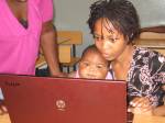
Youth map toilets in Mathare. (From Map Kibera's Blog)

I first heard about Map Kibera quite awhile ago. Looking through old blog posts, I’m thinking it’s been about 2 years. Somehow, probably through blogs and Twitter, we connected and made plans to work together on the Youth Empowerment through Technology, Arts and Media (YETAM) project that I was coordinating and where we (Plan) had been wanting to use digital mapping but didn’t have a clear understanding of how to do it technically.

Around the same time, Plan’s program team in Kenya was connecting with Map Kibera through the Institute for Development Studies (IDS), where Robert Chambers (the guru/godfather/grandfather of participatory rural development approaches) and co. were also thinking about how digital mapping fits into participatory development. Sammy Musyoki, Plan Kenya’s program support manager who is also affiliated with IDS, was already engaged in some work around the use of mobiles in community led total sanitation (CLTS) work. In November 2010, Map Kibera became part of a research project, where Sammy and Evangelia Berdou (also from IDS) began looking at “the challenges faced when applying the methodologies of participatory technologies to participatory development and aid.”

Importantly, the research is not ‘extractive,’ research, eg, the researchers are not coming into Kibera to pull information out and leave, publishing their work for academic circles and never bringing the insights back to the community for discussion and interpretation.

As Map Kibera Trust co-founder Mikel Maron wrote, “With IDS, all of the interviews and meetings were facilitated by Sammy, leading up to a gathering of everyone to reflect on the results. This was incredibly valuable for everyone to share their perspectives and understand others. We thought of it as Group Therapy.” (Note: the posts written during the research are collected here – more good reading.)

He continues, “Additionally, we organized an amazing inquiry led learning session with Aptivate, which contributes to creating a guide-book for future trainings.” (Note: I was following the Twitter stream during the sessions that Aptivate conducted, and I highly suggest checking this organization out.)

While the research was taking off, Plan Kenya and Map Kibera also started working together on both the YETAM project as well as on a Community-Led Total Sanitation (CLTS) program in Mathare.

The learning from the IDS research, together with Plan and Aptivate’s input around facilitating participatory development approaches meant that the Mathare project started off differently than the Kibera project did. The approach was a bit slower, and started by really engaging the community. As Jamie Lundine (current director of Map Kibera Trust) writes in her post Whose Map, “Map Kibera did not begin as a participatory development project. The initial project was an attempt to introduce open source technology – namely, OpenStreetMap – into a community that had previously not had a publicly accessible map (for all intents and purposes it was “unmapped”). Initial mapping of Kibera was done quickly (in 3 weeks) and local leaders, including administration were consulted but not necessarily engaged in the process.” The quick growth of the project was partly fueled by interest and support from the international community due to the innovative nature of the project, rather than by demand from the community for a rapid implementation.

She continues in the post to describe the participatory process that was used in Mathare – eg., lots of meetings, discussions and participation and offline activity before any mapping even started. The approach in Mathare was to really engage the community and local organizations and structures from the outset, and to “lead from behind”. One of the neat results from this approach is the fantastic Mathare Valley Blog, set up and maintained by the youth, and a great place to go to hear about what’s happening in Mathere directly from residents.

From Jamie’s post New Media in Mathare:

“To provide the participants with some ideas about other options in terms of new media, some basic training on the use of the Ushahidi Voice of Mathare platform was provided to some of the Map Mathare project participants. The Voice of Kibera team conducted a number of hands-on trainings with 8-10 Mathare participants. The participants were interested in the platform and learning from the experience of the Voice of Kibera members, but did not take-up the software as we saw in Kibera. We therefore agreed to provide technical support for the blogging platform as a central online information focal point for the Map Mathare initiative. We were careful not to impose the original ideas of New Media in Mathare and have adhered to the original methodology agreed upon by the team with support from Plan Kenya and CCS. This was a community driven approach from which the technical and coordination team “leads from behind”. We are and continue to be flexible when it comes to programming in Mathare.”

Map Kibera has worked with a broader group of Plan Kenya staff also to build capacity around participatory mapping so that various on-line and off-line mapping tools could be considered in Plan Kenya’s future efforts, for example, these suggestions by the Plan Kenya staff: mapping and identifying the hot spots of child abuse, use of SMS for communication with hearing and speech impaired within the community, using reports and sharing the same information to various media channels, program monitoring, a governance tool for enhancing social accountability as well as tracking projects, involving children in participatory community mapping, using blogging as a tool for youth to document governance issues, and to document and share participatory activities that Plan already undertakes, such  as transect walks and participatory situational analyses.

Map of toilets, water points and open defecation areas in Mathare. (from Map Kibera's blog)

Today, almost 2 years after our “first contact”, Jamie wrote a motivating post that highlights how things can work when development, technology, academia, communities and local partners work together openly.

“Mapping the sanitation in situation in Mathare has been a process of continual learning. When we began the Map Mathare pilot project in December 2010, we employed a dynamic methodology to engage young people and the community issues in the approximately 20 villages in Mathare. My colleague Primoz and I worked closely with the Plan Kenya team to design a training programme and over the past 8 months, have learned a great deal about working with youth and communities to “make the invisible visible” that is – to document tacit knowledge and turn the experience of communities and young people into information that translates across social and geographic boundaries.”

Through these collaborations, everyone benefits and learns. Plan is learning how to support communities to use new technologies in community development work. Plan staff is also developing capacity to innovate in Plan’s work by becoming more familiar with different technology tools and ways of working. Through blogging and sharing and face-to-face meetings, this learning is making its way through the organization, touching on a variety of levels, sparking slow and steady changes in how a huge organization operates. The Map Kibera team is learning more about participatory methodologies in development, which carries into their work and how they talk about their work also. IDS is learning how the two mix, and offering an academic overview within theoretical frameworks and advancing the field of knowledge around participation technology and participatory development. The community benefits by being fully engaged in a process that has positive and lasting impact.

Jamie writes:

“The team of mappers, videographers and bloggers– now about 15 in number – who have stuck with us since December of last year, can really tell you what empowerment means to them. Not only have they put themselves and their community on the map – a process that evokes a great sense of pride and responsibility. Some of the young people did not know how to read a map before…. 

Putting yourself on the map is the first step toward demanding recognition and everything that comes along with it – including basic human rights (the right to a clean living environment, the right to health) and by extension – the right to access services provided to the rest of Nairobi. Through our programme, young people are given the chance to represent their community through the medium of a map. Standard GIS symbols break down the barriers that separate youth and elders – rich and poor – and allow these young people to express themselves on a level playing field. Looking at the maps,  who would know they were generated by youth from the informal settlements?”

This is a good example of various disciplines and sectors working together with youth and community members to take an initiative forward in a very positive way.

It’s proof that coordination, cooperation and bridging across all these areas is not only possible, it is vital if efforts are to be of any real and sustained impact.

Read Full Post »

Ivan and Massilau working on some mapping in Inhambane, Mozambique.

I had the pleasure of working with Iván Sánchez Ortega in Mozambique earlier this month, and I learned a ton about the broader world of GIS, GPS, FOSS, Ubuntu and Open Street Maps from him. We also shared a few beers, not to mention a harrowing plane ride complete with people screaming and everyone imagining we were going to die! But I suppose it’s all in a day’s work.

Below is a cross-post by Iván about Maps for Mozambique. You can find the original post here, and a version in Spanish here. Note: the opinions expressed below belong to Iván and not to his former, current or future employeers…..

*****

Last week was a small adventure. I went to Mozambique to make maps, as part of the Youth Empowerment through Arts and Media program. The main goal was to train youngsters in order for them to make a basic cartography of the surrounding rural communities.

This travel is part of the Humanitarian OpenStreetMap Team activities. After the successes of Kibera and Haiti, we want to check how much we can help by providing cartography.

Cartography in developing areas provides a great amount of situational awareness – in order to help, one needs to know where the help is needed. In the case of Mozambique rural communities, we’re talking about knowing who has a water well and access to healthcare and education, and who doesn’t.

The problem with rural Mozambique is that the population is very disperse. Each family unit lives in an isolated set of huts, away from the other families in the community. There is so much land available that the majority of the land is neither used or managed.

Which leads to think that, maybe, the successes at Kibera and Haiti are, in part, due to them being dense urban areas, where a kilometer square of information is very useful.

It has been repeated ad nauseam that geographic information is the infrastructure of infrastructures. Large-scale humanitarian problems can’t be tackled without cartographic support – without it, there isn’t situational awareness, nor will coordinating efforts be possible, something very important in an era when aid can get in the way of helping. However, even with agile surveying techniques and massively crowdsourced work, the cost of surveying large areas is still big. And, as in all the other problems, technology isn’t the silver bullet.

—-

That said, the way one has to go to reach the rural communities doesn’t have anything to do with the occidentalized stereotypical image of rural sub-Saharan Africa. There are no lions, nor children with inflated bellies due to starvation.

There is, however, the image of a developed country but in which the public agencies work at half throttle. Mass transit, garbage collection, urbanism, civil protection, environment, job market, education, social security. Everything’s there, but everything works at a much lower level than one could expect. To give out an example, the Administraçao Nacional de Estradas (national roads administration) plans switching of one-way lanes over hand-drawn sketches.

The reasons that explain the situation of the country are not simple, not by far, but in general terms they can be resumed in two: the war of independence of 1964-1975 and the civil war of 1977-1992. Living is not bad, but also not good, and part of the population is expecting international humanitarian aid to magically solve all of their problems.

When one stops to think, the situation eerily reminds of the Spanish movie Welcome, Mr. Marshall. Only that everyone’s black, they don’t dance sevillanas, and instead of railroads they expect healthcare and education.

Wait a moment. A reconstruction 20 years after a civil war, external aid, and the need of cartography for a full country. This reminds me to the 1956-57 Spain general flight, popularly known among cartographers as the American flight.

These aerial photographs, made in collaboration with the U.S. Army Map Service, had a great influence in the topographic maps of that period, and even today they are an invaluable resource to study changes in land use.

—–

Which is, then, the best solution? To inject geospatial technology may be a short-term gain, long-term pain in the form of 9000€/seat software licenses. Mr. Marshall won’t come with a grand orthophotogrameric flight. Military mapping agencies won’t implement SDIs (spatial data infrastructures) overnight. Training aid workers and locals into surveying is possible, but slow and expensive, although it might be the only doable thing.

Related posts on Wait… What?

Mapping Magaiça and other photos from Mozambique

Being a girl in Cumbana

Putting Cumbana on the map — with ethics

Inhambane: land of palm trees and cellular networks

It’s all part of the ICT jigsaw — Plan Mozambique ICT4D workshops

Read Full Post »

I spent the first 2 weeks of November in Mozambique working on the continuation of the Youth Empowerment through Arts and Media project. This year, we are piloting digital mapping in addition to the other ICT tools that we’ve been integrating into the project. We weren’t able to find anyone locally in Mozambique who could train on Open Street Map but luckily were able to link up with Portuguese-speaking Iván Sánchez Ortega from OSM in Spain. (In case you didn’t catch the link – the official language in Mozambique is Portuguese…)

Iván was a great trainer and the youth from the two associations (Vuneka and Litanga) that we are working with really took to the idea of digital mapping and learning some new skills in the area of painting, theater, print journalism, radio, video and blogging. See some of Ivan’s thoughts on this Maps for Mozambique post.

Here are some photos of the work we did while in Mozambique….


Read Full Post »

Plan just released a new report called ICT Enabled Development: Using ICT strategically to support Plan’s work. The report is part of an on-going process by Plan Finland (kudos to Mika Valitalo for leading the process) in collaboration with Plan USA to support Plan’s country offices in Africa to use ICTs strategically and effectively in their development work. It was written by Hannah Beardon and builds on the Mobiles for Development Guide that Plan Finland produced (also written by Hannah) in 2009.

The idea for the report came out of our work with staff and communities, and the sense that we needed to better understand and document the ICT4D context in the different countries where we are working. Country offices wanted to strengthen their capacities to strategically incorporate ICTs into their work and to ensure that any fund-raising efforts for ICTs were stemming from real needs and interest from the ground. Plan offices were also in the process of updating their long-term strategic plans and wanted to think through how and where they could incorporate ICTs in their work internally and with communities.

The process for creating the report included 2-day workshops with staff in 5 countries, using a methodology that Mika, Hannah and I put together. We created a set of ICT training materials and discussion questions and used a ‘distance-learning’ process, working with a point person in each office who planned and carried out the workshop. Mika and I supported via Skype and email.

Hannah researched existing reports and initiatives by participating offices to find evidence and examples of ICT use. She also held phone or skype conversations with key staff at the country and regional levels around their ICT use, needs and challenges, and pulled together information on the national ICT context for each country.

The first section of the report explains the concept of ‘ICT enabled development’ and why it is important for Plan and other development organizations to take on board. “With so many ICT tools and applications now available, the job of a development organization is no longer to compensate for lack of access but to find innovative and effective ways of putting the tools to development ends. This means not only developing separate projects to install ICTs in under-served communities, but looking at key development challenges and needs with an ICT eye, asking ‘how could ICTs help to overcome this problem’?

Drawing on the research, conversations, workshop input and feedback from staff, and documented experience using ICTs in Plan’s work, Hannah created a checklist with 10 key areas to think about when planning ICT-enabled development efforts.

  1. Context Analysis: what is happening with ICT (for development) in the country or region?
  2. Defining the need: what problems can ICT help overcome? what opportunities can it create?
  3. Choosing a strategy: what kind of ICT4D is needed? direct? internal? strategic?
  4. Undertaking a participatory communications assessment: who will benefit from this use of ICT and how?
  5. Choosing the technology: what ICTs/applications are available to meet this need or goal?
  6. Adjusting the content: can people understand and use the information provided for and by the ICTs?
  7. Building and using capacity: what kind of support will people need to use and benefit from the ICT, and to innovate around it?
  8. Monitoring progress: how do you know if the ICT is helping meet the development goal or need?
  9. Keeping it going: how can you manage risks and keep up with changes?
  10. Learning from each other: what has been done before, and what have you learned that others could use?

The checklist helps to ensure that ICT use is linked to real development needs and priorities and appropriate for those who are participating in an initiative or a project. The report elaborates on the 10 key areas with detailed observations, learning and examples to illustrate them and to help orient others who are working on similar initiatives. It places the checklist into a 4-stage process for ICT integration.

  1. Understanding the context for ICT work: includes external context and internal experience and capacity
  2. Finding a match between priorities and possibilities: rooting the system in local needs and priorities and finding good uses for tools and applications
  3. Planning and implementing concrete initiatives: carrying out participatory assessments, linking to other development processes and addressing technical issues and concerns
  4. Building a culture of systematic, sustained and strategic use of ICTs: linking ICTs with program work, transforming the role of ‘the ICT guy’, and building expertise on the cultural and social aspects of ICT use

Additional material and case studies, ICT country briefings, and an overview of Plan’s current work with ICT4D in Africa are offered at the end of the report.

The report includes input from Plan staff in Ghana, Mali, Mozambique, Senegal and Uganda who participated in the ICT4D workshops. It also draws heavily on some of the work that Mika has been doing in Finland and Kenya, and work that I’ve been involved in and have written about in Mali, Cameroon, Mozambique, Ghana, Benin and Kenya involving staff, community members and community youth. You can contact Mika to get the workshop methodology in French or English or to comment on the report (ict4d [at] plan [dot] fi).

There’s so much rich material in the report that I almost want to summarize the whole thing here on my blog, section by section, so that people will take the time to read it…  I think this is a really important and useful piece of work and we’re very excited that it’s now available! Download it here.

Related posts on Wait… What?

ICT4D in Uganda: ICT does not equal computers

Demystifying Internet (Ghana)

It’s all part of the ICT jigsaw: Plan Mozambique ICT4D workshops

A positively brilliant ICT4D workshop in Kwale, Kenya

7 or more questions to ask before adding ICTs (Benin)

A catalyst for positive change (Cameroon)

Salim’s ICT advice part 1: consider both process and passion (Kenya)

Salim’s ICT advice part 2: innovate but keep it real (Kenya)

Meeting in the middle

I and C, then T (US)

Read Full Post »

mGESA mobile mapping application

I wrote about a mobile mapping tool called mGEOS a few months ago, mentioning that I’d probably get a chance to try it myself in late July. Well that is just what happened.

I was at a workshop on ICT4D, including digital mapping, in Kwale, Kenya, and Peter Njuguna from Plan Kilifi’s District office came to share mGESA (aka Mobile Geographical Services for Africa) with us.

As far as I can tell, the difference between mGEOS and mGESA is that mGESA is a tailored application of mGEOS, designed together with Plan’s community based front-line staff for their specific information collecting and geo-visualization needs in Kenya.

Update: mGESA was the name for the pilot project. The final application is called PoiMapper (see www.pajatman.com). You can give it a try by downloading it and installing it on your mobile!

According to Njuguna, “the application is designed to run on simple mobile phones that have GPS capability and on which you can run applications.” It’s installed on the phone in the picture (update: the phone is a Nokia 6700 classic).

Njuguna explained “In Kilifi, we diverted from the route of going for applications that are there on the shelf or buying an application over the counter. We went the route of developing an application from scratch. We are working with various partners. We have Plan in Finland, we have Plan in Kenya, we have the University of Nairobi and we have the company Pajat in Finland. Plan Kilifi is the implementing office. So that is where we are coming from.”

The project has been on-going for 7 months. The first thing to define, according to Njuguna, was “Why do we need mapping? Why do we need GIS in the first place? Well, we need GIS to enhance the work we are doing and to try to answer some of the questions we are asking on a day to day basis. So that’s why we wanted to incorporate GIS into our work. Everything we’ve developed is towards helping us answer questions and make decisions in our program and sponsorship work. We wanted to build something that would suit our needs.”

The end users of mGESA are front-line staff in Plan Kilifi District office, and eventually in all of Plan Kenya’s district offices. “Kilifi front-line staff have all been involved in developing the application. The first step was developing a list of points of interest, for example, schools, hospitals and health centers, interest groups, water sources, trading centers, and the like; and outlining the kind of information that staff regularly collect about the points of interest for use in their work.

mGESA points of interest

“Developing the points of interest was a challenge,” said Njuguna. “It might look like we just sat down and listed them. But it has been a process. We had to go over and over it. We had to be sure the questions made sense, that the questions that we were asking were the right ones and made sense to people in the field.”

mGESA was tested in the field for the first time in mid-July. Njuguna and the team are hoping to kick off in another 3-4 weeks and start collecting the actual data. When the points are mapped out using the mobile application, then they are uploaded to a server that links with Google (or other) maps. The team is exploring the possibility of getting Kenya maps with administrative boundaries to use as the mapping platform. The data collected in mGESA can be exported into excel and .pdf files.

Peter let me try out mGESA while we were doing some GPS mapping in Kinango. He was using the opportunity to test accuracy, and whether mGESA was pulling in the same coordinates as the Garmin GPS units that we were using (it was). I found the data collection process to be quite simple. You basically arrive to your point of interest, take the point on the phone, and scroll through a menu to select pre-existing information (such as name of the district, type of point, etc.) or fill it in yourself. You can take a photo of the POI if your phone has photo capabilities (which most GPS enabled phones should have). I didn’t get a chance to upload data to the server or the web to see how easy that process is.

Peter Njuguna, ICT coordinator at Plan's Kilifi District Office

The group at the workshop had just been trained on several ICT different tools, so they had a lot of questions about mGESA for Njuguna:

What phones does it work on?
Any phone with GPS and capability to download an application will work.

Does it use up your airtime?

mGESA will work on the phone even without any airtime, but during testing, it seemed to work faster with about 10 shillings of credit (equivalent to about $.13).

Is mGESA free?

No. The application is in development and will eventually end up on the commercial market, via Pajat Management in Finland.

Can the application produce a base map or only points?

It can map points of interest only.  Later on it should be able to map out lines (roads) and areas.

mGESA data points on the web interface

Where do the points of interest go?

The points of interest that are collected on the phone are downloaded via a USB cable onto a computer, in the same way that you would download photographs from a camera. Then the points are uploaded to the on-line platform, and also then they will be visible on top of a Google map or other kind of map.

Is mGESA compatible with Open Street Maps?

Now that we know about OSM, this is something we shall look into, as it could be quite useful.

Will the information that you collect be public or private?

At this point the information will be closed, because the application is still in development.  Also for privacy reasons, some information will be shared and other information not shared. For example, if we are collecting personal information on individuals, or data that could put someone at risk, this will not be shared on the map.

What types of uses will the application be suitable for?

Plan can use mGESA when determining plans for phasing out of one area and moving into another area, for example. Instead of collecting data and indicators on paper, staff and managers can see this information on a map and the information that is collected can help us to know where to work.  Having the points of interest mapped out and linked with development information, and being able to select out different information layers on the map (on the internet) should make these decisions easier and more sound.

Will communities be involved and able to use mGESA for their own purposes?

Yes, communities will be able to use the information collected to make their own decisions. Communities can also purchase mGESA for their own use. We might also say to them, come and bring your phone and we will install this application so that you can use it for your own purposes.

Why are you developing a software from scratch and that costs money to the end user if there are existing tools available?

We know that GPS gadgets are expensive and so we thought – why not look into a mobile option. We also had very specific ideas and needs, and we had people willing to develop the idea from scratch. It’s a customized application based on our existing information needs and systems, and we can collect it by mobile rather than trying to find and purchase GPS units here in Kenya.

Update: see this post on Mobile Active for more information on the continued piloting of PoiMapper.

Related posts on Wait… What?

mGEOS: a mobile mapping tool

A positively brilliant ICT4D workshop in Kwale, Kenya

Youth mappers: from Kibera to Kinango

Salim’s ICT4D Advice Part 1: consider both process and passion

Salim’s ICT4D Advice Part 2: innovate but keep it real

Modernizing birth registration with mobile technology

Read Full Post »

Yesterday my colleague Mika Valitalo at Plan Finland sent some information about mGeos, a cool project that Pajat Management (a Finnish company), Plan Kenya, Plan Finland, Helsinki University of Technology and University of Nairobi have been collaborating on for the past year. Note: Mika and Pertti Lounamaa from Pajat gave me written permission to share this info.

The idea? To develop easy-to-use GPS-based mapping software that runs on low-cost mobile phones.

Detailed map information is missing from most of the 'developing' world

What needs is mGeos responding to? Being efficiently able to provide health, education and humanitarian aid or even most industrial services is critically dependent on knowing where to provide these services. Basic location information about points-of-interest (POIs), routes to them and areas to service are missing from the countries in most need of public service improvement. In ‘developing’ countries especially, critical map and location information is largely incomplete, outdated or missing. For example, in the image here, you can see small town map details available for Finland (left image) vs for those for Kenya (right image).

Earlier experiences in a few program countries as well as responses to a questionnaire conducted with Plan Kenya staff showed a desire and clear need to use location data more effectively. There is also a need to make it available on low-cost phones that are more accessible.

Stefanie Conrad (my awesome boss) for example, sees it like this:

“Geographic analysis of the distribution of social services such as wells, hospitals, telecommunication facilities, broadcast services, schools, etc. is essential for Plan’s program work in order to have a sound understanding of the best way to provide access to those services. In reality, most of our country offices work with non-geographical systems, for example, lists of communities. In many countries, the government itself does not have sufficient mapping of communities in place. Decisions on where to put something to guarantee access to populations often becomes a thing based on best guess.

Mobile phones with GPS could support more equitable and technically sound placement of basic services. Digital pictures and maps could be used with communities in order to facilitate discussions about where to best place a well, for example. This can often be a difficult process, as usually community leaders try to get these types of services to be conveniently placed as close as possible to their own homes….  Many of our offices also have difficulties producing the maps needed for corporate communications (area overviews, local area maps, etc) – this would become possible with GPS.”

The mGeos project aims to respond to these identified needs. A 3-month field pilot is planned to take place in Kilifi, Kenya, in July.  I’ll be in Kenya in July and if the pilot goes forward then, I am hoping to be able to see personally how mGeos works!

What are mGeos’ key features?

  • mGeos service platform

    Supports collection of structured data as numbers, text, exclusive and multiple choice and images; and also location data including points of interest, routes and areas

  • Multiple front ends:  standard internet browsing for laptops and large screen smart phones and mobile browsing (xHTML/WAP)
  • Dedicated application for GPS enabled mobile phones
  • Authoring tool for defining forms and corresponding database model for storing the collected data
  • Open API for accessing stored data
  • Based on a SaaS (software as services) model

What does the mGeos system consist of?

  • client software which runs on low-cost S40 GPS enabled mobile phones (eg. Nokia 2710)
  • server running a database where all the collected information is stored and accessed
  • portal i.e. webpages which show the collected Points of Interest (POIs) on Google maps (or other maps) and allow browsing, exporting and sorting of the collected data.

What would mGeos look like in action?

Say a field worker named Victoria arrives to the Kilifi District Program Unit in the morning. She’s planning to visit Kujemudo community. Before leaving for the day trip, she takes a GPS enabled mobile phone from the office and downloads the latest updated ‘Points of Interest’ (POI) list from the computer to her phone.  The POI list has been created by Victoria and her colleagues by gathering location data while visiting different communities during the past couple of months.  Today Victoria also wants to map important POIs in the communities, among many other tasks.

After arriving to Kujemudu and having a meeting with the local community based organization, Victoria rides her motorbike over to a school building in Ezamoyo village, takes her GPS enabled mobile phone in hand, and starts the mapping application.  The she chooses ‘add POI’ from the menu, selects the POI category of ‘school’ and adds the name of the school. After that she also types in the additional information such as the number of pupils and teachers, ownership of the school, etc.  Finally she takes a photo of the school, attaches it to this record and saves the information to the phone memory to be transferred later to the computer server.

Next Victoria visits Mkombe village where the location and information of the school has already been entered into the database by her colleague Peter a few weeks earlier.  Victoria uses the POI browsing feature to find the right school (browse by POI category).  When she finds the existing data record, she chooses ‘edit’ in order to update the information. Because part of the school has been reconstructed, she takes a new photo of the school and replaces the outdated one. Also, since the number of students has increased, she edits the ‘school population’ field to match the current number. Finally she saves the record.

While visiting Mabirikani village the next day, Victoria checks one of the wells, because she has heard that it has collapsed due to recent floods.  Since this is clearly the case, Victoria takes the mobile, searches the well from the data base and marks the record as deleted.

mGeos web screen shot

The next day, Victoria arrives to the Kilifi District Program Unit, connects the phone to her computer, and uploads all the new records and changes. Then she sends them to the mGeos webpage, which gets updated (i.e., now all the users can see the Ezamoyo school building, the updated information from Mkombe, and will notice that the well in Mabrikani is no longer in use).

When Victoria sees the new information in the system, she notices that she has mistyped the number of pupils in Mkombe school.  Since she is the author of the information, she can also edit the record in the mGeos webpage to correct the information. After checking that all the other information is OK, she leaves the phone in the office and continues with other work tasks.

When will it be tested? We plan to fully test the application in Kenya in July. Plan Kenya/Kilifi District Program Unit has identified a number of  POIs ( schools, health facilities, water points, trading centers etc.) they would like to map. They have also listed additional information each POI should have. For example, for schools they would collect information on: name, type (special, integrated, non-integrated), level (primary, secondary…), numbers of pupils, availability of water and sanitation services, etc. etc.  This information would be entered into mobile phones running mGeos software and later transferred to the server for sharing, analysis, editing, reporting and exporting.

Once the pilot has run, and user input is collected, the system will be adjusted and improved so that it can be fully launched.  I’ll keep following the mGeos story and post more as it’s tested and rolled out!

Update:  For more information see these later posts:

mGESA: Mobile GEographical Services for Africa

Mobile Date Collection through Points of Interest in Kenya (on Mobile Active)

The final application is called PoiMapper (see www.pajatman.com). Give it a try by downloading it and installing it on your mobile!

Read Full Post »